
http://www.nationalatlas.gov/mapmaker?AppCmd=CUSTOM&LayerList=federallands&visCats=CAT-boundary
Great map, it shows each state, county, and what the land is used for.
Very strange that in Nebraska for example the USA does not own the Federal Court House Land, or the capital.
Now the State of Nebraska is a subdivision of the USA, so they are essentially the same government.
I have been told that most all government buildings like court houses are leased land.
>>>>
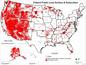
The above map shows the percent of each state owned by the USA.
- Nevada 84.5% < 10 highest percent owned.
- Alaska 69.1%
- Utah 57.4%
- Oregon 53.1%
- Idaho 50.2%
- Arizona 48.1%
- California 45.3%
- Wyoming 42.3%
- New Mexico 41.8%
- Colorado 36.6%
- Connecticut 0.4% < 10 lowest percent owned.
- Rhode Island 0.4%
- Iowa 0.8%
- New York 0.8%
- Maine 1.1%
- Kansas 1.2%
- Nebraska 1.4%
- Alabama 1.6%
- Ohio 1.7%
- Illinois 1.8%
SEE > https://gisgeography.com/federal-lands-united-states-map/
Click HERE to view the list of foundational information created by Lawyer Paul John Hansen to aid in independence from the US System.
U.S. federal land is land owned by the government of the United States. The United States federal government owns between a quarter and a third of the total land in the United States, approximately six hundred forty million acres of it. The total land area of the United States is just over 2.4 billion acres.
>>
| # | State | Federal Land | Total Area |
|---|---|---|---|
| 1 | Nevada | 80.1% | 110,572 mi² |
| 2 | Utah | 63.1% | 84,897 mi² |
| 3 | Idaho | 61.9% | 83,569 mi² |
| 4 | Alaska | 60.9% | 665,384 mi² |
| 5 | Oregon | 52.3% | 98,379 mi² |
| 6 | Wyoming | 46.7% | 97,813 mi² |
| 7 | California | 45.4% | 163,695 mi² |
| 8 | Arizona | 38.6% | 113,990 mi² |
| 9 | Colorado | 36.2% | 104,094 mi² |
| 10 | New Mexico | 31.7% | 121,590 mi² |
| 11 | Montana | 29% | 147,040 mi² |
| 12 | Washington | 28.6% | 71,298 mi² |
| 13 | District of Columbia | 24.7% | 68 mi² |
| 14 | Hawaii | 20.2% | 10,932 mi² |
| 15 | New Hampshire | 14% | 9,349 mi² |
| 16 | Florida | 12.9% | 65,758 mi² |
| 17 | Georgia | 12.9% | 59,425 mi² |
| 18 | Michigan | 10% | 96,714 mi² |
| 19 | Arkansas | 9.4% | 53,179 mi² |
| 20 | Virginia | 9.3% | 42,775 mi² |
| 21 | North Carolina | 7.8% | 53,819 mi² |
| 22 | Vermont | 7.8% | 9,616 mi² |
| 23 | West Virginia | 7.4% | 24,230 mi² |
| 24 | Minnesota | 6.8% | 86,936 mi² |
| 25 | South Dakota | 5.4% | 77,116 mi² |
| 26 | Wisconsin | 5.3% | 65,496 mi² |
| 27 | Mississippi | 5.1% | 48,432 mi² |
| 28 | Tennessee | 4.8% | 42,144 mi² |
| 29 | Louisiana | 4.7% | 52,378 mi² |
| 30 | South Carolina | 4.5% | 32,020 mi² |
| 31 | Kentucky | 4.3% | 40,408 mi² |
| 32 | North Dakota | 3.9% | 70,698 mi² |
| 33 | Missouri | 3.8% | 69,707 mi² |
| 34 | New Jersey | 3.6% | 8,723 mi² |
| 35 | Maryland | 3.2% | 12,406 mi² |
| 36 | Alabama | 2.7% | 52,420 mi² |
| 37 | Delaware | 2.4% | 2,489 mi² |
| 38 | Pennsylvania | 2.2% | 46,054 mi² |
| 39 | Texas | 1.9% | 268,596 mi² |
| 40 | Indiana | 1.7% | 36,420 mi² |
| 41 | Maine | 1.5% | 35,380 mi² |
| 42 | Oklahoma | 1.5% | 69,899 mi² |
| 43 | Illinois | 1.2% | 57,914 mi² |
| 44 | Massachusetts | 1.2% | 10,554 mi² |
| 45 | Ohio | 1.2% | 44,826 mi² |
| 46 | Nebraska | 1.1% | 77,348 mi² |
| 47 | New York | 0.8% | 54,555 mi² |
| 48 | Rhode Island | 0.7% | 1,545 mi² |
| 49 | Kansas | 0.5% | 82,278 mi² |
| 50 | Connecticut | 0.3% | 5,543 mi² |